viator

Viator

Wednesday, October 14, 2015

Carving a piece of cambodia


Clink, clink, clink. Every strike of the hammer sends my chisel plunging into rough sandstone, dislodging tiny chunks which scatter haphazardly across the table. A tingly ache has begun to creep up behind my hunched-over back while dripping beads of my forehead perspiration dissolve into damp speckles on the red, earthy surface of the stone block.
It is Sunday afternoon, and I am learning the traditional Cambodian art of stone carving in the modest workshop of 31-year-old Poy Khet, a professional craftsman. An hour into incessantly chipping away at a square slab, an exquisite Romdoul flower — the national flower of Cambodia — is slowly but surely beginning to take shape.
“One by one, not too strong,” says Khet as he watches me struggle to control the strength exerted from my hammer. Carving the delicate contours of the flower’s petals prove to be the most difficult task for the day, and he soon takes over from my clumsy strikes and awkward balancing. Like knife slicing through a milky butter slab, the instrument weaves seamlessly in and out of the narrowest corners of the stone under Khet’s skilful hands.
Minuscule stone flakes drift off freely into the wind, like a cloud of colliding particles caught in a dust storm. It is a hypnotizing spectacle of magic; within seconds the intricately curved outline of the flower’s teardrop-shaped petals emerge into view.
In Cambodia, Khmer stone sculptures are ubiquitous- along the unpaved roads, in obscure corners of grubby places, nestled within lush greenery of forest wilderness or hawked as valuable wares in thriving marketplaces. A stone deity stands right smack in the middle of a bustling traffic junction in Phnom Penh. With eyes shut and hands in a meditative position, she cuts an imperturbable figure of serenity as vehicles around her whir by.
Over in Siem Reap, two white, glorious lion stone sculptures with manes are perched proud along a sparse and dusty sidewalk. They stare forbiddingly into the distance, the striking richness of their detail incongruous with their comparatively underdeveloped environment. Peppered all over the land, these distinctive stone sculptures are the humans of Cambodia – upright, impregnable and unscathed by the constant flux of the city. 
But it is in the splendorous Angkor Wat, the first stop of my temple tour, where the most magnificent stone carvings can be found. The art of stone carving has been around for time immemorial, having flourished since the foundation of the Khmer nation. Entirely constructed from sandstone, Angkor Wat’s grandiose Khmer architecture is a sight to behold even from a great distance. It is nearly impossible to miss the pointed peaks of the temple’s iconic lotus bud towers thrusting into the sky, bearing down upon the milling tourist masses like a watchful tyrant overlooking his kingdom.
Almost every part of Angkor Wat is emblazoned with intricate carvings steeped in Hindu and Buddhist mythology, from its meandering walkways to its tall doors, thick pillars and even ceilings. From murals depicting elaborate goddesses and monkey gods and demons waged in war, all riddled in the most convoluted detail, to towering sculptures like the symbolic Buddha naga (an enlightened Buddha is seated on the coils of a giant cobra), each and every stone carving has a fascinating story to tell.
Engraved into every nook and cranny of the temple’s rugged walls are bevies of bare-breasted dancing nymphs, heads enshrined with sophisticated headgear and bodies clad with only a limp sarong.
“These are Apsaras,” my guide Thoeun Bunthy tells me. In Hindu legend, Apsaras would gainly dance to music created by their husbands the Ghandarvas, who served as court musicians in the palace of gods. Over 1,800 stone carvings of these celestial and divine female beings line the exterior and interior of Angkor Wat, their arms contorted in an array of lithe positions that seem poised to break out into graceful dance.
Along a dark and secluded corridor in a tower, a row of headless grey statues settle lonesome on thick pedestals. With the jarring absence of their heads, they cast shadows against the walls forlornly as warm sunlight streaming in through the windows illuminates their nondescript pockmarked bodies. To the average tourist on first sight, these elusive statues bear little semblance of any individuality or identity, but I soon learn from Bunthy that they are Buddha sculptures which were beheaded during the Khmer Rouge.
In 1979, the Khmer Rouge under leader Pol Pot tried to completely obliterate Buddhism, killing monks, religious intellectuals and destroying Buddhist institutions. Any representations of the Buddha were desecrated; soldiers ravaged the vicinities of temples and cut off the heads of Buddha sculptures to sell them for money in the black market. “Too expensive to restore. They want to keep history,” says Bunthy, pointing to a jagged indent left in the wake of a dismembered stone neck.
Back in the stone carving workshop, for a moment my mind wanders off. And that is when it happens: I accidentally chip away a corner of stone with the chisel, leaving a petal with an unsightly dint in the corner. My heart sinks and I cry out in dismay at the seemingly costly mistake. But Khet comforts me as he takes the chisel from my hands.
He manoeuvres the instrument with deft precision and ease, intensely scraping around the sides to even out the rough chip. Reminiscent of a skilled surgeon in an operating theater, his level of focus is astounding, never once stopping to look up until the edge of the dint has been completely smoothed. “When I work, I don’t see anyone who walks by. I see stone only,” says Khet, who has been carving stone for 17 years.
After Angkor Wat I visit Bayon Temple in the late evening, renowned for its 216 charmingly smiling stone faces of the Bodhisattva Avalokiteshvara carved into every side of its 54 towers. Each massive face projects a serene display of absolute composure, as though nothing could possibly disrupt their sublimely tranquil state of being. “The gods smile for the people, so the people can live in peace and happiness,” explains Bunthy, pointing toward the sky.
As I stare up at their comfortingly upward curved lips and closed, thick eyelids, for a moment I understand what he means. Wherever I roam in the temple, it feels like the eyes of every stone face, each facing a different direction of north, south, east and west, are trailing me. Ever omnipresent, these larger-than-life gentle giants live quietly among the citizens of Cambodia, hiding in plain sight, but watching over them from afar. They are the secret guardians of the city; waiting, protecting.
I finally lay down my chisel after close to three hours of carving. A beautifully shaped Romdoul flower stone candle holder, with a small circular yellow lily candle placed in its hole, lies before me. “You okay?” Khet asks quizzingly, looking at my flushed face. “Hard work right?”
Indeed. Fragments of stone and dust envelope the surface of the work table, like a mini excavation site. “But you do good, you faster than other tourists,” he adds. I ask him how long it takes for him to carve the same flower from sandstone. “Too fast,” he laughs sheepishly. “An hour and a half.”
For something which took a copious amount of effort and time, it is barely the size of my palm, measuring merely nine by nine centimeters. Yet what follows is an overwhelmingly indescribable feeling- almost surreal- as my fingers slowly close upon the now washed and polished stone flower, tracing every painstakingly carved defined contour, curve and swirl. It hits me then: I made this.
I leave the workshop carrying my precious homemade memento close to me, grateful that I have a piece of Cambodia to take home.

                                                                      tours for cambodia

Sunday, August 9, 2015

Argentina:Losing it at the End of the World

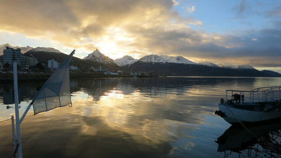
A sunrise at "the end of the world."
A sunrise over the water in Ushuaia. Photo by Olivier Guiberteau
I thrust my hands deep into my coat pockets, a refuge from the biting cold. The Beagle Channel stretches before me. An angry wind growls in from the sea. Great hulking ships sit dormant in port. Monsters of nautical travel — ice breakers — Antarctic ships. The frozen continent lies 1,000 kilometers to the south. Bronze busts of past explorers line the waterfront, staring wistfully out to sea. I have no idea who any of them were — but if their clothing, steely gaze and sensational facial hair are anything to go by they were quite something.
I have been stranded in Ushuaia for three weeks now. The result of waltzing away from an ATM without retrieving my debit card first. A replacement was making the slow, agonizing journey from England. I wasn’t entirely sure how — but judging by its speed I suspected by rowboat. There certainly were worse places to be stranded. Stevenage, for example, or anywhere in Nebraska. Nevertheless, I was sure I was only days away from complete insanity.
Ushuaia sits at the far southern extremity of Argentina, on a small island evocatively named Tierra del Fuego, The Land of Fire. A name that was given by the first European visitors who saw the frozen land alive with the fires of native Yaghan tribes. Today the Yaghan are long gone, and so are the fires. The snow has certainly remained. Pressed tightly between the Martial Mountains and the Beagle Strait, and effectively ringed by snow-capped mountains, the town’s setting is quite extraordinary. It has long been romantically dubbed “The End of the World.”
Travel here is Argentina has its own pace. My days have taken on a Groundhog Day repetition. Icicles greet me on the outer walkway as I rush quickly into the cozy warmth of the kitchen. The Antarctica Hostel has become home. Despite its name, it is pleasantly heated and filled with warm, agreeable people. I breakfast at 8 a.m. — a large coffee with cereal, followed by some toast and a second coffee. Always in that order. Occasionally I consider altering my system — but I fear what might happen.
Sunrise is late this far south. A little before 10 a.m. the uniform gray sky begins to evolve into vibrant blues, and clouds burst with a candy-floss pink before settling into a deep rusty orange. I wrap myself with excessive layers, strap a backpack to my shoulders and venture out into the blustery world.
A yawn escapes me, it’s long and deep and I savor every moment of it, stretching my arms to their limits. A powerful gust of wind snaps me out of my bliss. I shudder violently for a few seconds until it subsides. And so begins my day.
I approach the port and pass the angry, ranting sign with an enormous cross through a Union Jack, and words to the effect of “No English Pirates.” The Argentine government has again begun to beat the old war drum over their claim to the Falkland Islands.
The Saint Christopher, known as The HMS Justice in a former life, appears; a small forlorn ship run aground in 1954. She now acts as a monument to the regions many shipwrecks and lives lost. It sits lonely and dejected on a sand bank, black birds littering the wreck — standing guard. They remind me of the ravens at the Tower of London. A man with a more questionable mental stability might believe they never leave their posts, as they always seem to be in exactly the same spot. But I assume they’re simply on some kind of shift rotation. They eye me suspiciously as I walk past — a true Hitchcockian nightmare.
The Saint Christopher sits on a sand bank. Photo by Olivier Guiberteau
The town begins to widen. A tiny slither of land cuts a small lake off from the harbor. A broken muddied road runs along it and up to the naval base. I walked there once, and was fiercely rebuked for taking pictures of an old plane sitting ceremoniously outside. A large man with a large gun looked dementedly enraged, his eyes bulging, and his face contorted in a manner that generally either accompanies war or debilitating constipation. I’ve since developed quite a real fear of being water boarded as an English spy. I avoid the naval port these days. I’m not entirely sure what I would say under torture.
My path diverges here. Sometimes I walk through the residential area of the town and onto the old train line that snakes through the pine trees and winds up in to the hills. Inmates of the now closed prison were once brought here to collect timber in freezing conditions, an awful punishment. Sometimes I amble along the trail, occasionally I tackle the hill that borders it. What begins as a pleasant stroll quickly becomes a treacherous climb that involves hauling myself up and over sheets of ice. If I was honest with myself I would know that this would be extremely dangerous to return over. I’m always honest with myself — but I rarely listen.
Recently I saw a wolf in the woods. The beast stood motionless ten meters from me. Its shaggy gray fur speckled with snow, its eyes deep blackened moons. We greeted each other with the same look of shock and disbelief. Our eyes remained locked for several seconds. I feared war was moments away. Thankfully it ran away first, which I took as a small victory, but promptly ran the other way.
Sometimes I clamber up the abandoned ski slope that tumbles down the mountain side just outside of the town. The reward for the slippery climb to the summit is instantaneous. The world sings gloriously out to the horizon — and into a different country. The small town of Puerto Williams, Chile, lies across the motionless water. The southernmost town in the world is the last stop before the foreboding Cape Horn.
The forest stretches back a mile or so from the ridge before hitting the mighty wall of the Martial Mountains, which tower up with a giddy steepness, finishing in anger somewhere near the clouds. On my first visit to the area I spotted a cross-country skier moving quickly toward me.
The wooded area around the abandoned train line in Ushuaia, Argentina. Photo by Olivier Guiberteau
“Hola,”I hollered as he approached. He glared at me and shot past without a word. I watched his agile shape disappear into the distance, as I attempted to suppress both a feeling of hurt and an impulse to hit him with a snowball.
When I grow tired I head for home. I always walk along San Martin, the main business street. Shops pack closely together — it still has the feel of a traditional main street, but the few upscale boutiques hint at what the future may hold.
I expected something much more basic than what I found in Ushuaia. The “End of the World” brings visions of a wilderness hardship. San Martin has a brisk and prosperous feel to it. Just today, for no other reason than my sad slow demise into insanity, I was gazing aimlessly into a shop window which seemed solely dedicated to taps. You may think, as I did, that the end of the world might well be satisfied with the one tap — at a stretch two — but no. I counted, then re-counted 14 different types of sink taps, all of which looked roughly identical to me. Each came complete with a cheery, slightly exotic name — Ashia, Marta — Liberty. If a society is ever to be judged on taps, I suspect Ushuaia will do rather well.
The communal area in the hostel is busy. The bus back from the nearby ski slopes has just returned, disgorging people with that healthy glow that comes from a day on the slopes. Among them, the Brazilians I am sharing a room with beckon me over, but I have my usual business to attend to first. I walk to the front desk with both hope and resignation.
“Any post for me?” I ask Carla behind the desk. She used to try and vary the way that she would let me down. Now she just shakes her head sadly.
I usually take a stroll in the evening to work off dinner. If the stroll becomes a little strenuous and I happen to work up a thirst, I stop at a local bar. I’ve become very fond of the El Almacen de Ramos General, a wonderfully warm and homely old-style bar. It’s filled with antique knick-knacks, such as ancient train sets and elderly typewriters. My inner child begs me to play with them. Sadly, all of them come with a stern little sign informing people like me not to touch them.
They know me there now.  I’ve stopped pretending that I was planning on sharing that liter of beer with a friend. In turn they have stopped looking at me in the funny way that you look at a man sitting alone in a bar, on a Tuesday evening, consuming beer delivered in a large jug. Sometimes I go a little wild and order another — because let’s face it — it’s not as if I’m going anywhere tomorrow.
  View the original article here

                                       Tours for Argentina 

Thursday, July 30, 2015

Romantic Hawaii-kauai for couples

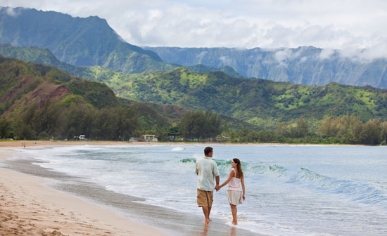
Kauai is a popular destination for honeymoons and romantic vacations.
Kauai has long been popular with those seeking a romantic getaway.
With its beautiful beaches, roaring waterfalls and unforgettable sunsets, Kauai is a natural draw for those seeking a romantic getaway. After all, with such natural beauty surrounding you, it’s easy to feel amorous.
But romance isn’t just about gazing happily into each other’s eyes – it’s about experiencing new things together and creating shared memories that you can savor for years. And as many visitors have found, Kauai serves up plenty of unique experiences along with Mother Nature’s bounty.
Home to some 69,000 people, Kauai has a slow, relaxed way of life. You’ll feel that laid back spirit as soon as you land at the airport in Lihue. The majority of towns on this Hawaiian island are small. Even Kapaa, the biggest town on the island, has only 10,700 inhabitants. This means that small town friendliness and charm are the norm.
Those seeking big-city shopping or entertainment won’t find it here, but couples who want to explore the Hawaiian outdoors and savor the simple pleasures of good food, friendly people and beautiful landscapes will not be disappointed.
Travel in Hawaii is popular all year-round. Kauai’s weather is ideal, with average temperatures in the mid-70s to mid-80s. So it’s the perfect place to get outside and explore.
The Couple That Plays Together, Stays Together
You can only sit around and stare into each other’s eyes for so long. In Kauai, you can get outside and explore together.
With more than 50 miles of golden sand beaches and an abundance of hiking trails, the question is where to start your adventure. The western east side of the island is home to the 3,567-foot deep Waimea Canyon, sometimes called “the Grand Canyon of the Pacific,” while the 3,000-foot mountain cliffs of the Napali Coast are something to see, either by air, by land or by sea.
The best way to explore the island is with an experienced outfitter. They know the island best and that local knowledge goes a long way in creating a memorable experience. Here are a few suggestions:
Princeville Ranch on the North Shore offers a ride to a waterfall and picnic lunch. Photo by Janna Graber
Horseback Riding to Waterfalls
Tucked away in the lush grasslands of the North Shore, Princeville Ranch offers horseback riding tours that meander through rich pastures in the shadow of the dramatic Hanalei Mountains. From there, you can tie up your horse and take a short hike to an 80-foot waterfall for a picnic and a swim. Yes, the scene may look like life in a postcard, but this is everyday life in Kauai. Be sure to wear your swimsuit under your clothes and take a towel and sunscreen.
Sailing the Napali Coast
Capt. Andy’s has been taking visitors sailing along the Napali Coast for more than 35 years. They offer snorkeling tours, whale watching or sunset sails, depending on the time of year. The catamaran boats are large and comfortable and the captains and crew are well-known for their humor and entertaining commentary. And the scenery? Incredible.
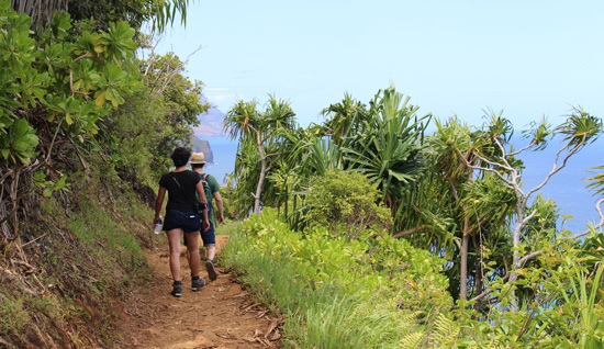
Hiking the Napali Coast is a great way to see the coastline up close. Photo by Janna Graber
Hiking the Napali Coast is a great way to see the coastline up close.
Hiking the Napali Coast
If you’d like to see more of the Napali Coast up close – or if sailing isn’t your thing – take a hike along the coast instead. Kayak Kauai offers guided small-group hikes to Hanakapiai beach. Their expert guides are not only fun to be with, but provide insight most visitors would otherwise miss. At the beach, hikers have a picnic lunch and a swim before heading back. Be sure to wear your swimming suit under your clothes and wear good tennis shoes or hiking shoes.

Stand Up Paddle Boarding
Even if surfing is not on your to-do list, stand up paddling is something almost everyone can do. Outfitters Kauai, well-known for their zipline adventures, now offers a calm river stand up paddleboard tour. The calm water part is important for first timers. The slow moving river water makes it easy to learn to paddleboard. After cruising down the river on your stand up paddle board, you’ll take a hike through the tropical forest to a short zipline and picnic lunch. Tip: Wear water shoes; it makes it easier to stand on the board and is good for hiking through the forest.
Driving the North Shore
If you have a car – and we’d recommend you do – be sure to save time to explore the North Shore. The tropical scenery is gorgeous and the small towns on the north shore are just so “Kauai” – with laid back locals, small not-to-miss eateries, art galleries and quirky stores selling everything from surf wear to macadamia nut ice cream. Take it slow on the roads. Much of the road system on the island consists of narrow two-lane roads that you’ll often be sharing with pedestrians (many who will be barefoot) and the ever-present wild chickens that roam the island. The North Shore has many one-lane bridges. Local courtesy is to allow 5-7 cars to cross at a time.
Haena Beach on the North Shore. Photo by Janna Graber
Hit the Beach
You can’t go far in Kauai without finding a gorgeous stretch of beach. But for your safety, it pays to know where to swim. During the summer, there are huge swells on the south shores, while large swells can be found on the north shore in winter. The ocean can be dangerous, especially the rip currents. The safest bet is to swim at lifeguarded beaches. The island has many of them. Some of the best snorkeling and swimming beaches are Ke’e Beach, Poipu Beach, Haena Beach Park, Anini and Salt Pond. A popular beach for camping is the remote Polihale Beach.
Stargazing
This last activity won’t cost you a dime; just head outside when it’s dark and look up. Most of the island remains in its natural state, with little development. This means that there is little light pollution on the island, and on clear evenings the night skies are amazing! Just find a beach chair or lay back in the grass and soak in the beauty of the night skies with your love.
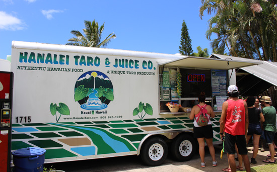
There are many small food trucks like Hanalei Taro & Juice Co. that offers tasty Hawaiian food. Photo by Janna Graber
There are many small food trucks like Hanalei Taro & Juice Co. that offer healthy, tasty Hawaiian food.
Where to Eat in Kauai
In Hanalei, head to BarAcuda for tapas and wine with friends. If you’d rather have something fast, stop at the food truck called Hanalei Taro & Juice Co. for yummy authentic Hawaiian food such as laulau, kalua pig, poi, lomi salmon, and kulolo. The Wishing Well Shave Ice truck (right across from the Hanalei Taro & Juice Co truck) is also something you’ll want to visit. Try the shave ice with macadamia nut ice cream inside. If you want to catch some local music and vibe, get some pizza or just a beer at Tahaiti Nue, also in Hanalei.
The Eating House 1849 in Poipu is prominent Hawaiian chef Roy Yamaguchi’s latest creation. Eating House 1849 pays homage to Hawaii’s vibrant culinary heritage with locally-sourced dishes like Plantation Paella, 1849 Spicy Ramen Bowl (it’s huge and the flavors are incredible) and Chicken Kamameshi. Don’t miss their signature chocolate soufflé.
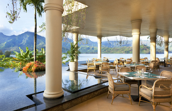
The Makana Terrace at St. Regis Princeville. Photo courtesy St. Regis Princeville
The Makana Terrace at St. Regis Princeville.
Our pick for the most romantic dining spot on the island goes to Makana Terrace at the St. Regis. The outdoor dining patio offers such a wide view of beautiful Hanalei Bay with the mountains in the background that it almost seems surreal. Go for their buffet breakfast or if you can, at sunset when the skies are filled with dark pinks across the blue colors of the bay.
Where to Stay in Kauai
The Cliffs
Princeville
If you’re the type that likes to cook your own meals and have a little more room and privacy, you might want to check out The Cliffs at Princeville. The resort offers one to two-bedroom condos on the cliffs overlooking the North Shore. Units can be rented by the day or week, and some of the units are even available as a timeshare exchange (if you are a timeshare owner).
Like many homes and accommodations in Kauai, The Cliffs condos don’t have – or need – air conditioning. Though the air may be warm outside, huge windows and ceiling fans allow the trade winds to keep the condo cool day and night. Each unit has a lanei with large table so you can enjoy most of your meals outdoors. There are BBQ facilities throughout the resort. Wild chickens wander the resort, adding to the cacophony of bird sounds that awaken you each morning. Banana, coconut and avocado trees dot the grounds. Lounge in the Adirondack chairs along the cliff and watch for whales or if you time it right, you can watch the sun set over the sea.
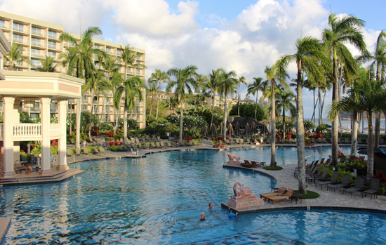
The Kauai Marriott is known for its amazing pools. Photo by Janna Graber
The Kauai Marriott is known for its amazing pools.
Kauai Marriott
Lihue
If incredible pools are your thing, the Kauai Marriott Resort on Kalapaki Beach might be right up your alley. The resort has an enviable location right on Kalapaki Bay, so you can swim and snorkel right from the resort’s beautiful beach. Golfers will like the 19-hole Jack Nicklaus-designed course at the adjacent Kauai Lagoon Golf Club. The Kauai Marriott Resort is large and airy, with five open-air restaurants to choose from. Each room offers the usual Marriott luxury touches and has a balcony to enjoy that great Hawaiian weather.
Ko’a Kea Resort
Poipu Beach
Those who prefer smaller boutique hotels might want to stay at Koa Kea Resort, which opened in 2009. Located in Kauai’s famous Poipu Beach area, the 121-room resort has a small beachfront, tidy pool, and upscale luxury rooms featuring modern design. Red Salt is the resort’s oceanfront restaurant, serving fresh Hawaiian produce and cuisine.
St. Regis
Princeville
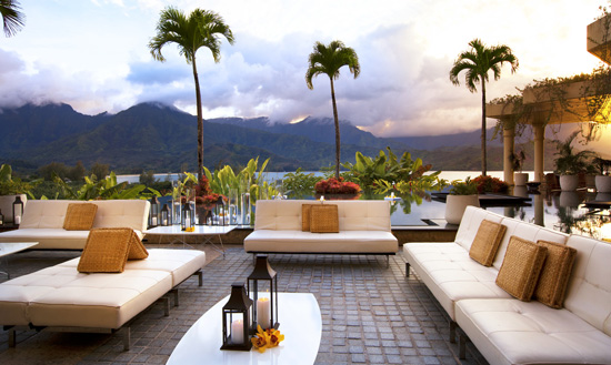
The St. Regis Princeville is one of the finest properties in Hawaii – and this is the place to consider if you’re planning something very special, such as an engagement, vow renewal or even a wedding. (Some 85 weddings are held here each year.) You can even arrange to have your own private dinner on the beach with your sweetheart.
The St. Regis Princeville is classy and sophisticated, but never stuffy or overdone. This is Hawaii, after all. Nature’s beauty takes center stage, with huge windows and open architecture taking advantage of the resort’s incredible location overlooking Hanalei Bay. The rooms offer unparalleled luxury and creature comforts, from bath salts to daily butler service available with certain room levels. Have dirty shoes from hiking Napali Coast? No worries. Your personal butler will ensure the shoes return to you looking almost new. With pampering like that, you might never want to leave.
Sunset at the St. Regis Princeville, a popular place for honeymoons and weddings. Photo by St. Regis Princeville
Sunset at the St. Regis Princeville, a popular place for honeymoons and weddings.
The Halele’a Spa at St. Regis Princeville has romantic spa treatments for couples, including the Napali Ritual of Energy and Balance, which includes a couple’s scrub, facial massage, couple’s soak and a couple’s massage. Oceanfront couple’s massages are also available in a cabana right on the beach.
No matter what your style and taste, you’re sure to come back from Kauai with many cherished experiences – and memories. Visitors to Kauai often come back and again, and chances are, you will too. Although you may travel to Kauai to celebrate the woman or man you love – you may just end up falling in love with Kauai as well.
 View the original article here

tours for hawaii click here

Tuesday, June 16, 2015

Exploring Turkey by Bus:Unexpected Adventures

Turkey
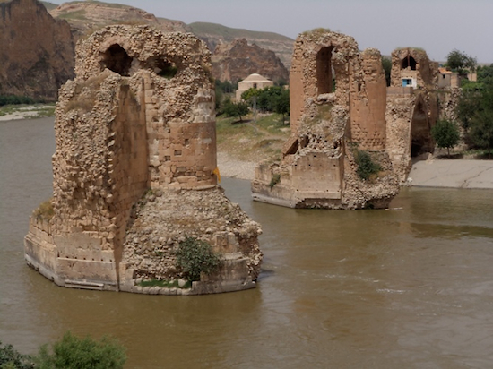
Old Bridge over river Tigris. Photo by Inka Piegsa
Until a few months ago, I lived in Didim near Bodrum on Turkey’s Aegean coast. Fascinating as the proximity of such outstanding archaeological sites as Ephesus, Pamukkale and Halicarnassus were, my itchy feet urged me to go further afield and to explore as much of the rest of Turkey as I could.
The best way to get around in Turkey is by long distance coach. There are several companies and the coaches are extremely comfortable and modern, providing drinks and snacks, TV and music and frequent stops along the way because they – mercifully – don’t have toilets. Attendants look after you, store your luggage, sprinkle your hand with lemon cologne and make your journey as comfortable as possible.
An added bonus is that surprisingly few foreigners use them, probably because of a totally unjustified prejudice that they aren’t safe. This means that once you are on the coach to the destination of your choice, at very reasonable prices at that, you are surrounded by locals. With typical Turkish hospitality, they even welcome the foreigner, share food and tea with them and, if you are able to utter only a few words of Turkish, they become your friends for life.
Early one morning, I boarded such a bus belonging to my favorite company KamilKoc. My destination was Urfa and Mardin in the far southeast of Turkey. It just so happened that I also made frequent trips to Istanbul and, on a visit to Istanbul Modern, the Museum of Modern Art, I came upon a photo exhibition featuring Hasankeyf in Mesopotamia, an ancient settlement on the shores of the river Tigris. Hasankeyf was in imminent danger of being devoured by the waters of a massive dam. These pictures were so mesmerizing that I decided on the spur of the moment to visit before it was too late.
The bus journey took more than 14 hours, but it was one of the most entertaining trips I have ever enjoyed. Hardly had the coach left the bus station, as my fellow travelers brought out the tapes and started to dance in the aisle. The bus shook so much from the festivities, I was afraid it might come off the road. Thankfully the driver was used to this kind of entertainment and kept it steady. Next were the food baskets, homemade pastries and other delicacies offered to the starving foreigner with a smile. They would not take no for an answer, even when my stomach reached bursting point.
Village of Hasankeyf. Photo by Inka Piegsa
Finally, we pulled into the central bus station in Mardin, a beautiful town spilling down a hillside in tiers of medieval buildings, narrow streets, mosques and workshops of the famous silversmiths of the region.
I took a taxi to my hotel which was on the top of the hill, just below a mosque and with fabulous views of the Tigris and the wide valley of Mesopotamia. I felt thrown back into biblical times sitting on the roof terrace and enjoying the very tasty and famous Mardin kebab.
The next day, I hired a car and asked the driver to take me to the river and Hasankeyf. In my experience, this is the best way to explore a country because you get a driver, interpreter, body guard and local expert rolled all in one. Ali didn’t disappoint.
The first thing he asked me after pulling up in his old but freshly polished Mercedes was if I had had breakfast. Nice as the hotel was, breakfast was nothing to write home about and I said so. He only lifted a finger and started jabbering on his mobile. Then he grinned. “Surprise, madam,” he said. “You’ll be my family’s guest”.
It turned out, that he took me to his home where his mother and sisters had laid on a Turkish breakfast spread for me, the likes of which I had never had before. We were sitting on the floor and comfy cushions and stuffing our faces with dish after dish and gallons of tea until it was time to set off for Hasankeyf. With kisses, embraces and good wishes we were finally on our way.
Panorama downstream. Photo by Inka Piegsa
Approaching the mighty river Tirgris and seeing the medieval bridge spanning the width of the waters is a sight you will never forget. Along the shore Kurdish shepherds were tending to their flock of goats and sheep, a scene straight from biblical times. I asked if we could go down and talk to them and that’s where having an interpreter comes in handy. They showed me how to milk a goat and a good laugh was had when I tried myself.
Perhaps it was just me, but the arches of the bridge looked to me like sad accusing eyes, as if they knew that modern times and the dam would put an end to their existence after hundreds of years dominating the mighty river Tigris. Not only is the bridge affected, but also countless manmade caves which line the surrounding mountains and other testimonies of time gone bye.
After many protests and stops to the project of the Illisu hydroelectric dam, the project was approved and relocation of the cave dwellers has already begun. Site like the mosque Ulu Cami and the Zeynel Bay Mausoleum will also be moved, similar to what happened in Abu Simble.
However, the place and its unique atmosphere will never be the same again, so visit before the waters devour a historic place which has survived for hundreds of years only to fall now victim to modern time. Whatever the final outcome, it’s one place in Turkey that you should not miss.
If You Go
The best way to reach Hasankey or Turkish Mesopotamia is by long distance coach from every major city in Turkey. There are several bus companies, the biggest one being METRO, KAMILKOC or Ulusoy. Urfa has an airport called Sunliurfa if you prefer to travel by plane. The region features continental climate with hot summer and cold winters. As for accommodation, there are many boutique hotels in Mardin and Urfa. If you’d like to find a private driver, it’s best to ask at reception.
Author Bio:  Born in Germany, Inka obtained law degrees in Germany, The UK and Spain, running her own international law firm for over 30 years in London and Marbella/Spain. A few years ago, she turned novelist, travel writer and photographer. Her novel ‘The Househusbands Club’ won Readers Favorite Award in the US in 2009. Her latest book, ‘Istanbul, city of the green-eyed beauty’ is a literary guide to Istanbul following the footsteps of authors Barbara Nadel, Orhan Pamuk and Pierre Loti. Her travel articles have been published in GoNomad, Europe Up Close, Off Beat Travel, Literary Traveler and many more. She is a regular contributor to Travel Generation, all exciting, weather2travel and spain-holiday.com and she has recently been commissioned by BBC Travel. Her blog www.glamourgrannytravels focuses on her solo travel adventures around the world with the emphasis on luxury and comfort. Inka has lived in Switzerland, Miami, London, Beirut and Istanbul and has currently settled in the South of Spain
View the original article here

tours for turkey click here

Wednesday, May 20, 2015

Hiking History: Ireland’s Beara Peninsula


As if on cue, tiny raindrops begin to fall as I hopscotch the final weather-lashed rocks leading to Lady Bantry’s Lookout. I deviate from a leafy stretch of the Beara Way in the Glengarriff Woods Nature Reserve, unable to resist scrambling up the half-mile detour to the lookout – my brief effort is exponentially rewarded.
Behind me, the Caha Mountains are illuminated by pinholes of sunlight piercing the water-bloated, gray clouds. Below, the still water of Bantry Bay spreads like a shimmering silver blanket, cradled by wind-whipped coastline. I pull my jacket out of my pack and the raindrops promptly dissipate. On Ireland’s Beara Peninsula, a rugged, 48-mile finger of land straddling counties Cork and Kerry, erratic weather is a tired cliché.
Beara is often overlooked by visitors making a beeline for the Dingle Peninsula or the Ring of Kerry. On my first trip to Ireland nearly two decades ago, I also missed Beara, sticking instead to the well-trodden tourist track. In fact, the first time I had ever heard someone mention Beara was barely 48 hours earlier — at a pub called the Goal-Post Lounge in the village of Shanagarry, along Cork’s southern coast. I was having a drink with some classmates after finishing a weeklong course at the Ballymaloe Cookery School. I had asked one on my classmates, Derval, if she was heading directly back to Dublin.
“Actually, I’m going to Beara, to a Buddhist Retreat Center,” she said. “It’s called Dzogchen Beara. If I can ever find the place.”
I pictured a Tibetan Buddhist sanctuary nestled into the countryside in some far-flung corner of Ireland. Beara seemed almost mystical. With a rental car, creased paper map, and 72-hours until my flight left Cork, I was going to Beara.
Now, as I descend the overlook trail, I lament my all-too-brief time in Beara — the backpacker’s paradise. The peninsula is bisected by mountains, laden with rolling hills, plunging valleys, highland lakes and forests — and entirely ringed by the 122-mile Beara Way, which forms part of Ireland’s longest walking trail, the extended Beara-Breifne Way, connecting ten counties from Cork to Leitrim.
The view from Lady Bantry Lookout in the Glengarriff Woods Nature Reserve. Photo by Malee Oot
I follow the Beara Way along an ancient road toward the village of Glengarriff, peeling off to hike the 2.2-mile Big Meadow Loop. I meander through lichen-fringed forests of sessile oak, downy birch, yew, rowan and strawberry trees giving way to long fallow meadows tinged with pink-petalled ragged robin and the purple cotton-ball flowers of Devil’s-Bit Scabious.
Despite the untouched feel, Beara has a long history of human habitation. Hundreds of relics of the peninsula’s earliest residents remain — more than 500 Neolithic and Bronze Age sites — providing insights into daily life in early Ireland. Humans have also long left their mark on Beara’s natural landscape, the peninsula is covered with copper mines. The mines were first used during the Bronze Age, and later, in the 19th century, became some of the most productive in Ireland.
The waters surrounding the peninsula also have a rich maritime history, particularly Bantry Bay. At the end of the 18th century, Bantry Bay almost became the staging point for a French supported invasion of Ireland led by Theobald Wolfe Tone. Part of an organization seeking to establish a republican-style government in Ireland, known as the ‘United Irishmen’, Wolfe Tone was deeply influenced by popular revolutions in France and the United States — and ultimately he was able to curry favor with France, which paid off militarily.
In the winter of 1786 a sizable French fleet — 46 ships and nearly 15,000 men — sailed for Bantry Bay. But, an easterly gale kept French armada stagnant, and ultimately winter weather prevailed, botching the invasion and forcing the flotilla back to France.
Steely clouds gather tightly overhead just as I reach clearing beside a small pond. A gust of wind ruffles low hanging leaves and raindrops begin to fall. Other than the rain, the forest is incredibly still. Peaceful.
A wildflower-studded view of Bantry Bay. Photo by Malee Oolo
But these woods were once witness to one of the peninsula’s most tumultuous periods — and the Beara-Breifne way actually retraces the perilous flight of Beara’s last chieftain. At the beginning of the 17th century, southern Ireland was in turmoil, and for Beara’s chieftain, Donal Cam O’Sullivan Beare, things were going downhill quickly.
After losing his stronghold — Dunboy Castle — to Elizabethan troops in June of 1602, O’Sullivan Beare was forced to regroup in the woods outside Glengarriff, launching guerrilla attacks on enemies, and surviving off a livestock herd hidden in the Coomerkane Valley. But when the English army seized the herd in the Coomerkane, faced with the real threat of starvation, O’Sullivan Beare led his 1,000 remaining followers (just over half of them women and children) through hostile territory and arduous conditions to join rebel leader O’Rourke of Breifne at Leitrim Castle. The journey took two weeks, and O’Sullivan Beare arrived in Leitrim with only 35 followers remaining.
As I cross the footbridge back to the parking lot, the sun reappears. I drive toward the town of Kenmare, in Kerry, paralleling the course of the Beara Way, steering the corkscrew mountain roads of the Caha Pass white-knuckled. I park along Kenmare’s fishing pier and walk away from the water, the towering steeple of Holy Cross church guiding me like a compass need toward the center of town.
A lone sheep keeps an eye on the road at a farm just outside the town of Kenmare. Photo by Malee Oolo
I dip into the cozy Kenmare Bookshop, in a neat, gray stone building. The first book to catch my eye is a collection of ghost stories — surely Beara has century’s worth of legends. Instead, I leave with a Henning Mankell novel. Back on the street, I pause and listen. In minutes, I am staring at a half-empty glass of dark stout as a furious fiddle riff begins in another corner of bar. I think I’ll stay for another pint.
If You Go
Get there: Fly to Cork (www.corkairport.com) and drive 90 minutes to Glengarriff – an easy starting point for exploring Beara and/or accessing the Beara Way trail.
More info: www.bearatourism.com
Author Bio:  Malee Oot was infected with the travel bug early — as the child of parents working in international public health, while growing up Malee had the opportunity to spend time living in Thailand, Kenya, and Nepal.   She is currently co-authoring a regional cookbook with sustainable recipes and energy-saving tips for the Washington, D.C. area.  Her writing has previously appeared in GoNomad, the Not For Tourists Guide to Washington, D.C., the Washington Post, and Political Moll.  Malee also writes a blog about outdoor opportunities in Northern Virginia (
http://novaoutdoor.blogspot.com/).  She currently lives in the Washington, D.C. suburbs with two very spoiled very rescue dogs.    Filed Under: Hiking • Historic Travel • Ireland • Small TownsTags: Beara Peninsula, Hiking, History, Ireland, Malee Oot, small towns
View the original article here

 tours for Ireland click here